DANGEROUS SEVERE THUNDERSTORM/TORNADO OUTBREAK AHEAD: A dangerous outbreak of severe thunderstorms and tornadoes is forecast across a large area beginning late tonight. A dynamic storm system will bring two rounds of severe thunderstorms.
ROUND ONE
*The broad window for the first round of severe thunderstorms will come from around 11:00 tonight through 8:00 a.m. tomorrow.
*SPC has defined an “enhanced risk” (level 3/5) for much of West Alabama for this event, with a “slight risk” (level 2/5) as far east and south as Scottsboro, Prattville, and Jackson.
*Highest risk of severe storms with “round one” will be over the western half of the state, mainly along and west of I-65. The severe threat is much lower over the eastern counties, where the air will be more stable.
*Where storms develop, they will be capable of producing hail and damaging winds. A few tornadoes are possible as well, mainly over West Alabama.
ROUND TWO
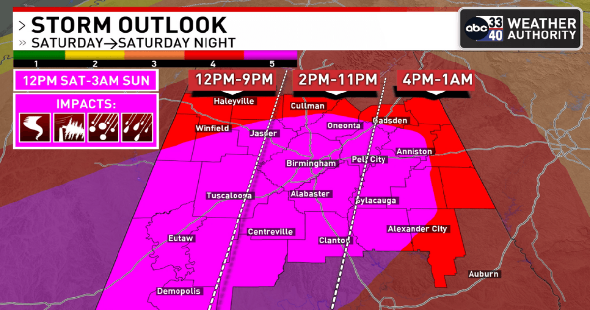
*This is the “main event”; the window is from 12 noon tomorrow through 3:00 a.m. Sunday.
*A rare “high risk” (level 5/5) has been defined for parts of Alabama and Mississippi, including Tuscaloosa and Birmingham. The rest of the state is in a level 4/5 risk. FYI the last high risk issued for a part of Alabama was on March 25, 2021.
*Storms will be capable of producing large hail, damaging winds, and tornadoes. A few violent, long track tornadoes are possible. This is a dangerous setup.
*A flash flood watch has been issued for the northern third of Alabama where the heaviest rain is expected, and a wind advisory has been issued for the northern 2/3 of the state. Gradient winds will gust to 30/35 mph at times.
KEY MESSAGES
*I don’t use strong wording often, but in this case it is needed. The threat is real, and the event is a dangerous situation for all of Alabama and most of the southern U.S. The goal is no loss of life, and no serious injuries; we all have a big role to play.
*It is critical that you hear warnings. An outdoor siren is never, ever a primary way of hearing warnings. The “siren mentality” has killed more people than anything else during tornado events in Alabama. The baseline for every home and business is a NOAA Weather Radio; unfortunately many retailers have sold out of them due to the high demand this week. On your phone, be sure emergency alerts are enabled in notification settings this is the tone you hear for tornado warnings and amber alerts. Have the free ABC 33/40 weather app installed. Turn the sleep/do not disturb modes OFF for the weekend so you will receive notifications at night.
*In your safe place, have helmets for everyone, including adults. Use a car seat for infants. Most serious injuries in tornadoes involve blunt force trauma above the shoulders. Wearing hard shoes is also a good idea. Have a portable air horn for everyone; they can alert first responders to your location if you are injured.
*If you live in a mobile home, know the location of the nearest shelter, or business open 24/7 that can serve as a shelter. Have transportation arranged so you can get there quickly. You cannot stay in a mobile home if you are in a tornado warning polygon.
*A car is a death trap during a tornado. If you are driving and get a tornado warning notification, pull off as quickly as possible and go into a gas station, fast food restaurant, or any other business that can serve as a shelter. Do not drive into a tornado warning polygon.
*You can be a hero. If you are reading this, you pay attention to weather. Let friends and family members today know this is a dangerous threat. During the event, if you have a friend or loved one in a tornado warning polygon, call or text them to let them know of the immediate danger. You can play a huge role in saving lives.
*Subscribe to the James Spann and ABC 33/40 YouTube channels so you can watch our live coverage. During the event itself all of my attention is focused on the live coverage. I simply am not able to respond to the hundreds of requests for individual briefings during a severe weather outbreak.
*Get the warnings, have a good plan, and we get through this together.
The sky will clear Sunday, but a few isolated showers are possible during the afternoon hours as the upper trough passes through.
NEXT WEEK: Most of the week will be dry, but a cold front will bring a band of showers and storms into the state late Wednesday and Wednesday night. For now it does’t look like a major severe weather threat See the video briefing for maps, graphics, and more details.
ON THIS DATE IN 1993: Birmingham’s low was 2 degrees, a record low for the month of March. It came when one foot of snow was on the ground from the Blizzard of 93.