Updated: 10:00 p.m. Mar. 14, 2025
A new severe thunderstorm watch has been issued for the majority of our area except Fond du lac and Sheboygan counties.
Storms moving across Illinois have the history of damaging wind gusts from 60 to 70 mph. Storms approaching our area will have a chance to gust to 60 mph.

____________________________________________________________________________________________________________
Updated: 9:00 p.m. Mar. 14, 2025
A new discussion for our area shows the potential for a severe weather watch to be issued for southeastern Wisconsin.

Showers and storms to our south have produced severe thunderstorm winds.
_________________________________________________________________________________________________
Updated: 8:00 p.m. Mar. 14, 2025
No changes to the ongoing forecast. Strong to severe storms have popped well to our west. There are severe thunderstorm watches outside of our area for the time being; however, that could change for our area.

If the storms hold their strength, I would assume a watch would be extended into southeastern Wisconsin.

We are expecting a line of showers and storms to move out of northern Illinois between 11 pm and 2 am. That line could produce damaging winds and an isolated tornado threat. The big question will be whether these storms hold their strength as they approach the lakefront.

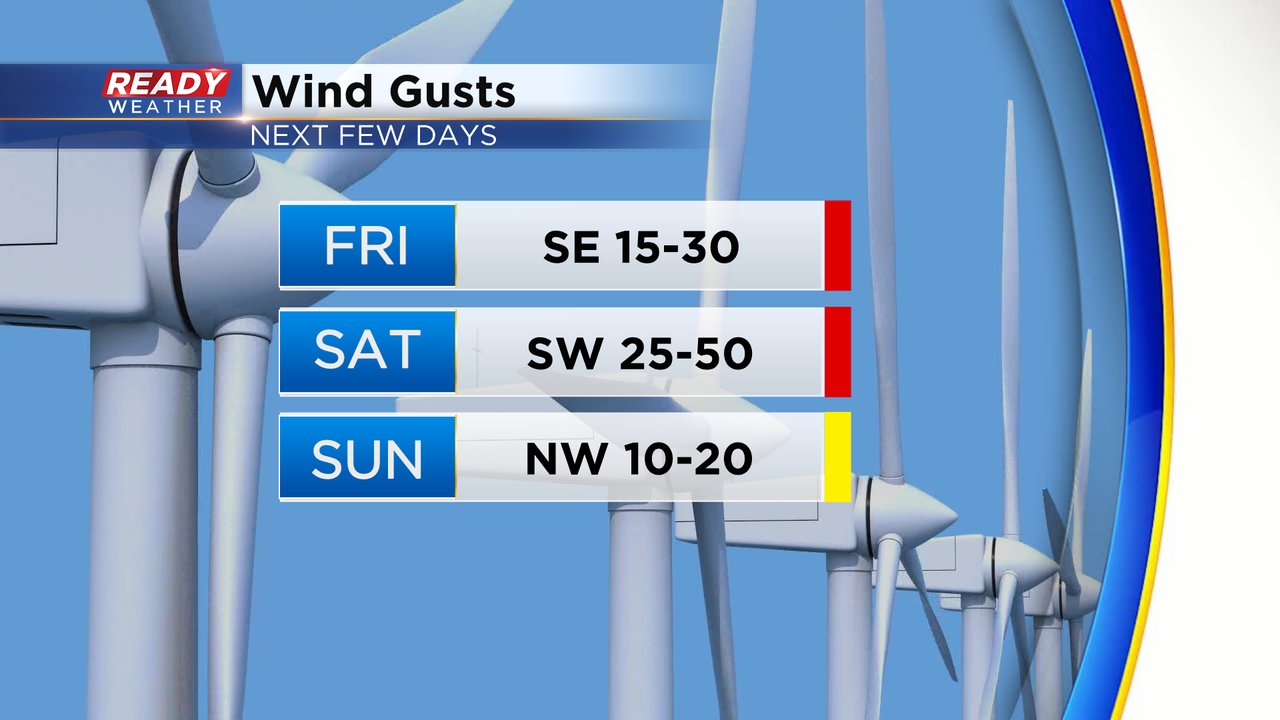
On Saturday a high wind warning has been issued for the morning for all of the counties in purple. Those areas could see gusts over 50 mph. A wind advisory has been issued for the entire area from 7 am until 5 pm.
______________________________________________________________________________________________________________
Updated: 1:15 p.m. Mar. 14, 2025
Temperatures are soaring! Moving in from the lake even 5 miles gets you to near 70 degree warmth, check it out:
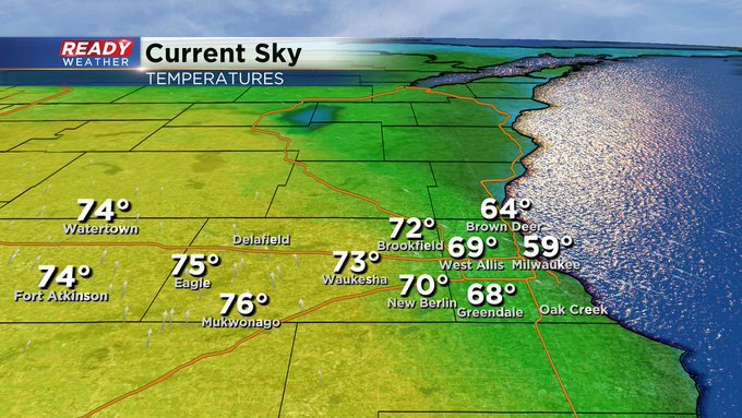
We sit in the sunny and windy warm sector this afternoon waiting for storms to develop out of Kansas in the vicinity of an area of low pressure.
This means we have all day to enjoy the bright, albeit breezy day. Storms still on track to arrive closer to midnight.
Despite the fact we continue to sit in a level one or two risk for severe weather the trend is definitely calling for a weakening trend. Gusty wind will be the primary threat for storms here tonight. Although can’t rule out some hail in the stronger cores, along with a period of downpours. The beneficial rain out of this system looks to fall in the quarter to half inch range.
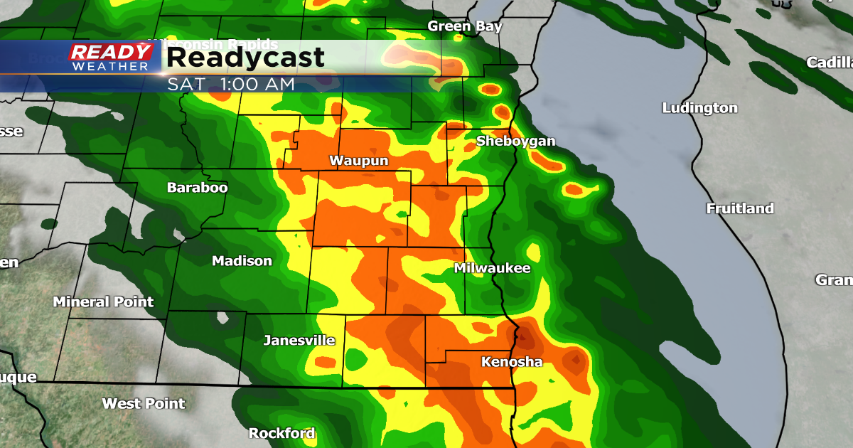
Updated: 9:50 a.m. Mar. 14, 2025
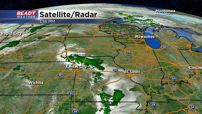
The few showers and storms we had this morning have now moved through southeast Wisconsin. Not everyone saw the rain but for those that did, it came with some downpours, lightning and some small hail.
Here’s a radar image that will update with time:

The rest of the forecast remains on track with the best timing for strong to severe storms in southeast Wisconsin from 10 PM to 3 AM. The latest severe risk from the Storm Prediction Center does bring a Level 3 Enhanced Risk (in brown) right up to the IL border and even a bit into Walworth County. As the line of storms is expected to weaken those that see it first, in our southwest counties, have the best chance to see some severe storms. The rest of southeast Wisconsin remains under a Level 1 (green) or Level 2 (yellow) risk for severe weather. The rest of the forecast outline below remains on track.

——
Posted: 6:09 a.m. Mar. 14, 2025
We have been blessed with a lot of sunshine this week. Those sunny skies turn a bit stormy as we end the work week Friday night but most of the day Friday will still be fairly sunny. A few isolated morning and afternoon showers or storms can’t be ruled out. We’ve seen a few pop up early Friday in central and south central Wisconsin.
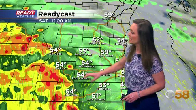
The better chance for rain will be with a line of storms that rolls in from the west late Friday evening through early Saturday morning. The best time for storms will be from 10 PM Friday to 3 AM Saturday. As the storms weaken some may not see much rain but others could get heavy rain and strong storms.

A Level 4 Moderate Risk, shown in red, is still in place to our south for parts of Illinois, Missouri and Iowa. That will be the bullseye for severe weather with the possibility of violent tornadoes. Locally in southeast Wisconsin we are under a Level 1 Marginal Risk, shown in green, for northern counties and Level 2 Slight Risk, shown in yellow, for our western and southern counties. The storms will likely weaken from the strength they have in Iowa and Illinois but some strong storms are still possible.
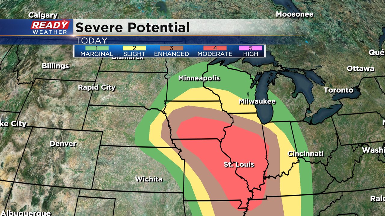
If we do see strong or severe storms in Wisconsin, damaging wind will be the main threat with over 60 mph gusts possible. Small hail and weak tornadoes cannot be completely ruled out with some brief street flooding possible.

Besides the storms, the wind will be very strong most of the next 48 hours. The wind speeds pick up during the day Friday with gusts reaching 30 mph by the afternoon. Friday night gusts reach 35 mph then on Saturday gusts will be strongest to 50 mph. Sunday will remain breezy with a 10-20 mph wind.
Download the CBS 58 Ready Weather app to track the storms with the interactive radar and see what part of the weekend looks most wet where you live.
Contributions to this story also made by: Rebecca Schuld