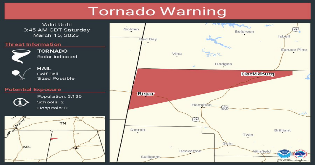
A tornado warning has been issued for northwestern Marion County including Hackleburg, AL until 3:45am:

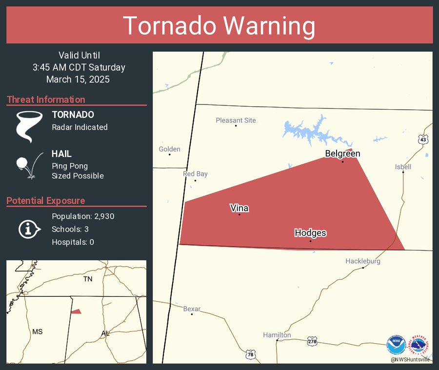
An additional tornado warning has been issued for southwestern Franklin County including Hodges, AL until 3:45am:
These are technically two separate warnings, but they are both for the same storm. One warning was issued by the NWS in Birmingham, and the other from the NWS in Huntsville. This can happen when a storm moves into a boundary between NWS offices.
This cell has a long history of producing damaging tornadoes. Please treat this warning very seriously, and get to your safe spot now if you are included in the warning.
Here are the full messages from the NWS:
The National Weather Service in Birmingham has issued a
* Tornado Warning for…
Northwestern Marion County in northwestern Alabama…
* Until 345 AM CDT.
* At 245 AM CDT, a severe thunderstorm capable of producing a tornado
was located over New Salem, or 7 miles south of Fulton, moving
northeast at 40 mph.
HAZARD…Tornado and golf ball size hail.
SOURCE…Radar indicated rotation.
IMPACT…Flying debris will be dangerous to those caught without
shelter. Mobile homes will be damaged or destroyed.
Damage to roofs, windows, and vehicles will occur. Tree
damage is likely.
* Locations impacted include…
Pigeye, Shottsville, Hackleburg, and Bexar.
PRECAUTIONARY/PREPAREDNESS ACTIONS…
TAKE COVER NOW! Move to a basement or an interior room on the lowest
floor of a sturdy building. Avoid windows. If you are outdoors, in a
mobile home, or in a vehicle, move to the closest substantial shelter
and protect yourself from flying debris.
—– —– —–
The National Weather Service in Huntsville Alabama has issued a
* Tornado Warning for…
Southwestern Franklin County in northwestern Alabama…
* Until 345 AM CDT.
* At 247 AM CDT, a severe thunderstorm capable of producing a tornado
was located near Evergreen, or 7 miles south of Fulton, moving
east at 30 mph. This cell has a history of producing tornadoes
across portions of central Mississippi.
HAZARD…Tornado and ping pong ball size hail.
SOURCE…Radar indicated rotation.
IMPACT…Flying debris will be dangerous to those caught without
shelter. Mobile homes will be damaged or destroyed.
Damage to roofs, windows, and vehicles will occur. Tree
damage is likely.
* This tornadic thunderstorm will remain over mainly rural areas of
southwestern Franklin County, including the following locations…
Hodges, Duketon, Atwood, Vina, and Little Bear Creek Reservoir.
PRECAUTIONARY/PREPAREDNESS ACTIONS…
TAKE COVER NOW! Move to a basement or an interior room on the lowest
floor of a sturdy building. Avoid windows. If you are outdoors, in a
mobile home, or in a vehicle, move to the closest substantial shelter
and protect yourself from flying debris.
Heavy rainfall may hide this tornado. Do not wait to see or hear the
tornado. TAKE COVER NOW!
Tornadoes are extremely difficult to see and confirm at night. Do not
wait to see or hear the tornado. TAKE COVER NOW!
Category: Alabama’s Weather, ALL POSTS, Severe Weather, Social Media