ORLANDO, Fla. – Get ready for an action-packed day of weather in east Central Florida!
We’ve got windy, warm conditions to start the day with showers and thunderstorms rolling in later this afternoon and evening.
Some of these storms have the potential to turn severe later in the day and evening hours. Due to this threat, the News 6 Pinpoint Weather Team has designated Sunday as a Weather Alert Day.
A tornado watch has been issued until 3 p.m. for locations including Marion and Flagler counties.
Tornado watch (Copyright 2025 by WKMG ClickOrlando – All rights reserved.)
[SEE THE LATEST WEATHER ALERTS IN YOUR AREA BY CLICKING HERE]
By Sunday afternoon, expect highs to climb into the mid to upper 80s across most of the region, with spots near and south of Orlando possibly hitting the low 90s. Along with the heat ahead of the front, we will also see wind gusts ranging from 25 to 35 mph, so a Wind Advisory will be in effect from 11 a.m. to 6 p.m. today.
Wind advisory (Copyright 2025 by WKMG ClickOrlando – All rights reserved.)
Forecast models continue to show the line of showers and storms pushing into north Central Florida by early afternoon. Last runs suggest that the storms will keep their strength as they approach early this afternoon, but things get a bit trickier when they move into our area later in the day.
The Storm Prediction Center has extended the Slight Risk (Level 2/5) for areas from Interstate 4 northward and a Marginal Risk (Level 1/5) for the rest of Central Florida.
SPC risk (Copyright 2025 by WKMG ClickOrlando – All rights reserved.)
Expect more scattered showers and storms to develop this evening, with some potentially strong wind gusts, hail, or even a brief tornado. Keep your eyes on the weather updates, especially after dark, and make sure you have a way to get alerts if necessary.
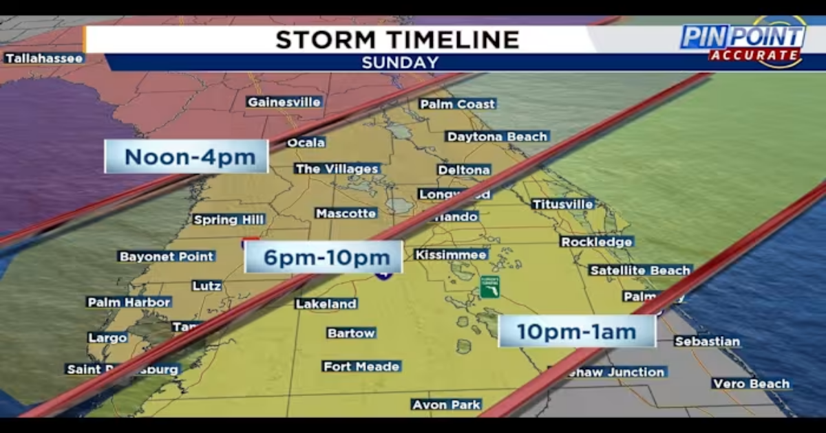
We are going to be tracking a line of storms into Marion and Flagler counties between 2 p.m. to 4 p.m. The front will slowly track south through sunset, approaching the I-4 corridor through 10 p.m. and finally clearing southern counties by midnight.
Storm timeline (Copyright 2025 by WKMG ClickOrlando – All rights reserved.)
Looking ahead to Monday and Tuesday, we’ll see a shift in winds as the cold front moves through. Winds will turn northwest on Monday morning, bringing cooler, drier air with them. Showers should wrap up by sunrise for most areas, with temperatures staying mild.
St. Patrick’s Day will still be breezy and temperatures will be much cooler, topping out in the upper 60s to mid 70s.
St. Patrick’s Day (Copyright 2025 by WKMG ClickOrlando – All rights reserved.)
The coolest part of the week comes Tuesday morning, with most areas starting in the 40s (and low 50s at the coast).
Tuesday morning (Copyright 2025 by WKMG ClickOrlando – All rights reserved.)
We’ll see a little rebound in the afternoon, with highs in the 70s for most places (though Volusia and northern Brevard may stay in the upper 60s). Winds will shift to the northeast and it may be breezy again at the coast in the afternoon.
So, in short, today is going to be busy, with some stormy weather to watch out for later in the day. Stay safe and stay updated on the latest forecasts!
Pinpoint Weather Insider
More Stories Like This In Our Email Newsletter