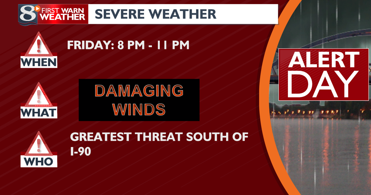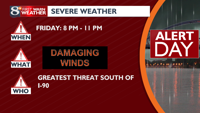
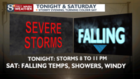
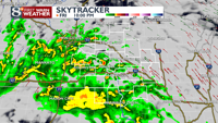
WHAT WE ARE TRACKING: A line of strong to severe thunderstorms capable of winds in access of 60 mph arrives this late evening with windy and much colder conditions in store for the weekend. Dry and milder conditions are likely for St. Patrick’s Day.
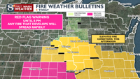
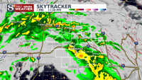
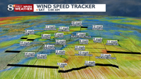
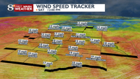
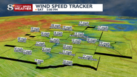
NEXT 24 HOURS: With relative humidity values dropping into the lower 30s (and even upper 20s) and wind speeds over 25 mph, elevated fire weather conditions are in place through the early evenings. Fire conditions are even worse in NE Iowa, where Red Flag Warnings are in place until 8 pm. Cloud cover quickly increases towards the evening commute as a strong frontal boundary lifts northeast into Iowa. A line of thunderstorms will develop along this front and surge northeastwards towards the region around 8 to 9 pm. Due to the already strong winds occurring and the bowing structure of this line, wind gusts over 60 mph are likely as the line lifts northeast across the area from 9 to midnight. Although a minor tornado threat exists within this line, the higher concern is damaging wind gusts. This line weakens as it pushes east/north of I-90 by midnight. The rest of the night looks quiet and less windy, with additional showers developing towards Saturday morning. This activity persists until noon as winds turn towards the SW and then to W, increasing speed. Most shower activity looks to stay along or north of I-90 with only light rainfall. Strong and gusty winds are likely Saturday afternoon as they gradually turn to the NW by sunset. Temperatures start the day around 50 degrees before gradually falling into the 30s by sunset. Although a few rain or snow showers are possible Saturday afternoon, most areas will remain dry. Breezy conditions continue Saturday, with temperatures falling into the upper teens to middle 20s by Sunday morning.
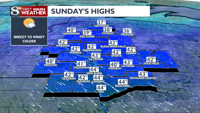
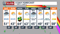
1. Temperatures drop below average (30s to low 40s) on Sunday under breezy conditions.
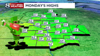
2. Above-average temperatures return on Monday and Tuesday, with highs in the 50s and 60s.
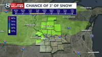
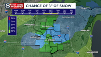
3. Rain/snow/wind returns Tuesday night through Wednesday night with snow accumulation
4. The best chance for snow accumulations of 6+ inches on Wednesday and lies north of I-90
5. Worse road conditions (slushy to snow covered) Wednesday afternoon and night
6. Cold but dry on Thursday (30s to low 40s) with seasonable temperatures on Friday (40s)
7. Dry on Saturday with highs in the 40s/50s
8. Light showers for Sunday and Monday with highs in the 50s
INTERESTED IN BECOMING A STORM SPOTTER?
Spotters supply vital information to your First Warn Weather Team and the community! Throughout March and April, the NWS La Crosse will be leading free training sessions for those who wish to become trained spotters! If you are interested, head to www.weather.gov/arx/skywarn to find the nearest upcoming class. Virtual classes are also being offered.
COPYRIGHT 2024 BY NEWS 8 NOW/NEWS 8000. ALL RIGHTS RESERVED. THIS MATERIAL MAY NOT BE PUBLISHED, BROADCAST, REWRITTEN OR REDISTRIBUTED.