ORLANDO, Fla. – A weather system that brought devastating tornadoes and severe thunderstorms to parts of the central and southern United States is expected to reach Florida on Sunday, which is why it is a FOX 35 Storm Alert Day.
Severe thunderstorms and tornadoes have already begun to impact parts of North Florida, near the Florida-Georgia State line. Here in Central Florida, Sunday will begin as a hot, humid and mostly sunny day, before the main storm system arrives in the afternoon and evening hours.
Here’s what to know about the latest weather alerts, storm forecast, timeline, and main weather threats.
Live weather updates
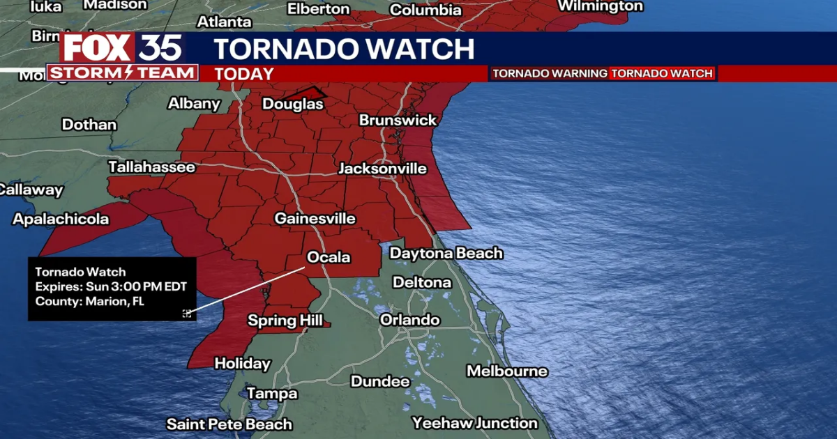
8 a.m. – At least 20 counties in Florida – including Alachua, Dixie, Flagler, and Marion continues in north-central Florida – are under a tornado watch until at least 3 p.m.
What’s the difference? A tornado WATCH means there is the potential for a tornado to form. A tornado WARNING means there is a radar-indicated or tornado spotter-confirmed tornado on the ground. When a tornado warning is issued, get inside immediately and find the most interior room in your house, such as a closet, bathroom, or room. You want to get away from windows, doors, and outside walls.
Sunday Forecast & Timeline
It will be hot, humid, and sunny in Central Florida to start the day before storms and potential severe weather arrive Sunday afternoon and evening. Highs will reach the upper 80s and low 90s.
The unstable air as well as the dynamics in the atmosphere will make for a severe weather threat this afternoon into the evening.
Main weather threats
The main weather threats are strong thunderstorms, lightning, heavy rain, wind gusts between 45 and 55 mph, and hail up to 1″ in diameter. There is also the potential for one or two tornadoes, according to forecasters.
When does the worst weather reach Orlando, Central Florida?

Storms are expected to reach Alachua, Dixie, Gilchrist, and Marion counties – those who watch us on FOX 51 – by early afternoon. The storm system is expected to reach the Orlando metro by late afternoon and evening.
Timeline:
- Ocala/Gainesville/The Villages: 1 p.m. to 4 p.m.
- Orlando/Sanford/Daytona Beach: 4 p.m. – 7 p.m.
- Titusville/Cocoa Beach/St. Cloud: 7 p.m. – 11 p.m.
The severe weather threat should end by midnight, as the storms make their way out of Central Florida.
Monday Forecast
Monday will be beautiful and much cooler compared to our Sunday. Highs fall back into the lower to middle 70s, and it’ll feel a lot comfier thanks to the lower humidity.
By the afternoon, we’ll see plenty of sunshine as high pressure takes over.
This high pressure center continues to build as we approach midweek, making for abundant sunshine and warming temps. Afternoon readings rise back close to 80° and climb into the lower 80s on Wednesday.

More radar maps from FOX 35 Storm Tracker Radar
STAY CONNECTED WITH FOX 35 ORLANDO:
The Source: This story was written based on information shared by the FOX 35 Storm Team.